|
PROPERTY #2
End of Deborah Drive
Acquired in 1973 - 3.13 Acres
Deed Record - Volume 264, Page 286
Map #34, Lot 72 Property List || SLT Home
Map
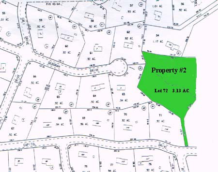
Description A certain parcel of land bounded and described as follows: Commencing at a point where the Northerly street line of Meadowlark Drive intersects the Southwesterly corner of Lot #37 - "Huntington Hills," now or formerly owned by T.J. Downs; thence proceeding along the Northerly street line of Meadowlark Drive in a curved line having a radius of 235.26' a distance of 15.24'; thence proceeding in a Northerly direction along property now or formerly owned by Capital Land Development Corporation and designated as Lot #61 - "Fox Hill Estates," a distance of 172.74'; thence proceeding in a Northwesterly and part Northeasterly direction in an irregular line along land now or formerly owned by Capital Land Development Corporation a distance of 555.35' to the Southwesterly corner of property now or formerly owned by Silva; thence proceeding in an Easterly direction along property now or formerly owned by Silva a distance of 640'+ or minus to the Northwesterly corner of Lot #45 "Huntington Hills" - in an irregular and bent line a distance of 618.02'; thence proceeding in a Southerly direction along the Westerly property line of Lot #37 - "Huntington Hills" to the Northerly street line of Meadowlark Drive a distance of 159.72' to the point of commencement. Said property being bounded as follows: NORTHERLY: by land now or formerly of Silva;
SOUTHERLY: by Meadowlark Drive;
EASTERLY: by lots #45, #44, and #37 - "Huntington Hills" - Section #2;
WESTERLY: by Capital Land Development Corporation.
Property List || SLT Home |