|
PROPERTY #3
Huntington Circle
Acquired in 1975 - 1.88 Acres
Deed Record - Volume 284 Page 20
Map #35 Lot 45 Property List || SLT Home
Map 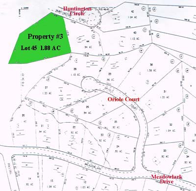
Description All that certain piece or parcel of land bounded and described as follows: Beginning at a point on the southwesterly street line of Huntington Circle, said point being 41.56ĺ southeast of a proposed monument, and being the north east corner of lot 16 as shown on said map. Thence proceeding along the southerly and easterly lot line of lot 16 the following courses:
S 68░ 59ĺ 40ö W 250.00 feet and S 350 41ĺ 45ö w 206.55 feet to a point on the northerly property line of land owned by the City of Shelton;
Thence proceeding along the northerly property line of the City of Shelton N 78░ 00ĺ 20ö W 125.49 feet and N 89░ 52ĺ 25ö W 287.61 feet to the southwest corner of lot 15 as shown on herein mentioned map. Thence proceeding along the westerly lot line of said lot 15 N 00░ 07ĺ 35ö E 243.42 feet to a point on the southwesterly Street line of Huntington Circle.
Thence proceeding along the southwesterly street line of Huntington Circle N 540 30ĺ 00ĺ. W 70.00 feet to point and place of beginning.
Property List || SLT Home |