| Shelton Land Conservation Trust, Inc. |
| Shelton Land Conservation Trust, Inc. |
|
Deed Record - Volume Page Map
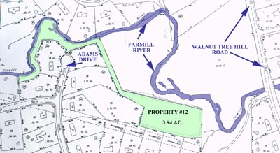
Description All that certain piece or parcel of land dedicated as open space to the City as shown on a record subdivision map entitled "Huntington Woods Section Four dated January 6, 1983" and on file in the Shelton Town Clerks Office as Map 1901, said land labelled as "Open Space" and bounded and described as follows:
Said parcel contains 3.84 acres. |
| SHELTON LAND CONSERVATION TRUST, INC. |
Shelton Land ConservationTrust, Inc. is a member of The Electronic Valley
Web hosting supplied by The ElectronicValley