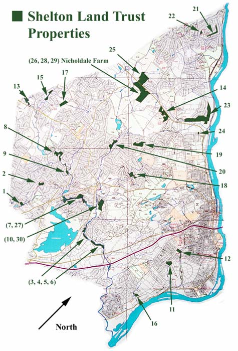
Trust Properties - Acres
1. End of September Lane - 3.40
2. End of Deborah Drive - 3.13
Huntington Circle - 1.88
3. End of Gristmill - 5.69
4. Commerce Drive - 3.89
5. Commerce Drive - 12.66
6. Far Mill Street - .30
7. Mulberry Lane - 20.68
8. Horse Stable Circle - 15.29
9. End of Adams Drive- 3.84
10. Off Lane Street - 17.15
11. End of Barbara Drive- 7.20
12. End of Sylvan Drive - 6.29
13. Mohegan Rd #1 - 2.97
Mohegan Rd #2 - 6.03
14. Birdseye & Rt. 110 - 23.06
15. Ballaro Drive- 3.90
Ballaro Drive #2 -4.84
16. Near Murphy’s Lane - 3.28
17. Thompson Street - 10.00
18. Captain’s Watch - 5.82
Dexter Drive - 3.68
19. Birdseye Rd/Tuckahoe Dr. 14.75
20. End of Tulip 7.60
Parallel to Cobblestone Dr. 2.70
21. Parallel to Rodia Ridge 3.07
Haiawatha Trail 5.14
22. End of Haiwatha Trail 2.17
23. Parallel to Tahmore Dr. - 15.10
Tahmore Dr./Village Dr. - 43.33
24. End of Woodsend Ave. -.99
25. Leavenworth Rd. - north -32.70
26. Nicholdale Farm - 44.87
27. Roaring Brook - 10.02
28. Crown Tool (Nicholdale) - 12.65
29. Nicholdale Addition - 3.06
30. Lane Street - 2.71